
Possible Earthquake Tremors Reported in Kampala and Central Uganda
Historical seismic data shows that since 1970, Kampala has experienced at least 25 earthquakes ranging between magnitude 2.0 and 4.5 within a radius of about 100 kilometers. Of these: Six earthquakes registered above magnitude 4.0, Eleven ranged between magnitude 3.0 and 4.0, Eight measured between magnitude 2.0 and 3.0.
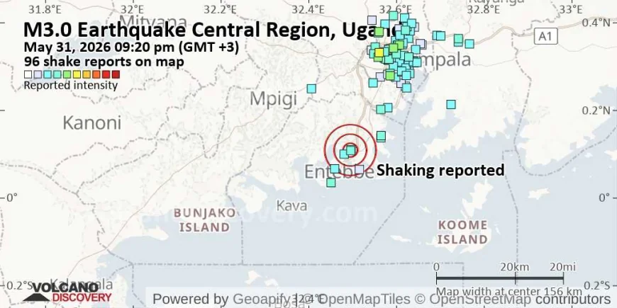
Residents across Kampala and several parts of Central Uganda were left startled on Sunday evening after a possible earthquake was reportedly felt at around 9:20 PM local time (GMT +3).
Although no official seismic agency had immediately confirmed the occurrence or magnitude of the tremor by press time, numerous residents took to social media and local communication platforms reporting noticeable ground shaking lasting several seconds.
The suspected seismic event is believed to have been felt in Kampala and surrounding areas, with some residents describing vibrations in buildings, rattling windows, shaking furniture, and brief moments of panic as people rushed outdoors to confirm what had happened.
Authorities and seismic monitoring agencies are yet to release official details regarding the epicenter, depth, or magnitude of the suspected earthquake. Experts say such information is usually confirmed after analysis of seismic data collected from regional monitoring stations.
An updated felt-report map circulating online indicated that the tremors were experienced in multiple parts of the Central Region, suggesting that the shaking may have been widespread.
Uganda lies within the seismically active East African Rift System, a geological zone where tectonic activity occasionally triggers earthquakes of varying magnitudes. While major destructive earthquakes are relatively rare in Uganda, minor to moderate tremors are periodically recorded across different regions of the country.
Historical seismic data shows that since 1970, Kampala has experienced at least 25 earthquakes ranging between magnitude 2.0 and 4.5 within a radius of about 100 kilometers. Of these:
Six earthquakes registered above magnitude 4.0,
Eleven ranged between magnitude 3.0 and 4.0,
Eight measured between magnitude 2.0 and 3.0.
The strongest earthquake recorded near Kampala in recent history measured magnitude 4.5 and occurred approximately 34 kilometers southeast of Njeru about 15 years ago.
Seismologists note that earthquakes in the East African region are associated with the gradual splitting of the African tectonic plate, particularly along the western and eastern branches of the Rift Valley system that pass through countries including Uganda, Kenya, Tanzania, Rwanda, and the Democratic Republic of Congo.
Following Sunday night’s incident, many residents remained alert as discussions about the tremor continued online, with some expressing concern over the possibility of aftershocks. However, experts emphasize that only official seismic agencies can confirm whether the event was indeed an earthquake and provide accurate scientific details.
Emergency authorities have not reported any casualties, injuries, or significant structural damage linked to the suspected tremor as of Sunday night.
The status of the event is expected to be updated once regional and international seismic monitoring agencies release official findings.

John Kusolo is a Pastor, Sports Enthusiast and Ugandan journalist with Nile Chronicles News (NCN). With a strong commitment to journalistic excellence, he is recognized for his dedication, goal-oriented approach, and ability to thrive in challenging environments. Kusolo brings focused motivation and professionalism to his reporting and media assignments.
















Comments (0)